SERVICES
The following services are offered, testified through the recent projects:
- Mapping and monitoring agricultural parameters with remote sensing
- Fusion of satellite images in crop models
- Assessment, provision and uncertainty estimation of regional climate projections and distillation of climate information to end-users
- Operational provision and assessment of regional weather forecasts
PROJECTS
In remote and proximal sensing of agricultural production and vegetation parameters:
| |
EU-H2020-SFS-38-2018 "Sino-EU Soil Observatory for intelligent Land Use Management - SIEUSOIL", 2019 - 2022. SIEUSOIL aimed to develop sustainable and holistic soil management practices based on a harmonized land information system suitable for diverse climate and operation conditions along different EU and China locations. A research platform consisting of advanced crop and soil sensing tools, modeling and data fusion, digital soil mapping and farm management information systems (https://www.sieusoil.eu/the-platform/) was developed to maximize land productivity and socio-economic benefits, while minimizing the environmental impacts. The SIEUSOIL platform provides Open Linked Data to monitor status and threats of soil and assist in decision making for sustainable support of agro‐ecosystem functions, while, through customizable modules, provides the wise management of soil at field level and demonstrates good practices on soil management both for EU and China. SIEUSOIL aimed to support sustainable management of soil, increase land productivity sustainably, reduce crop yield variability across time and space, and support the policy formulation process. Innovative practices and tools tested and demonstrated in SIEUSOIL were found to have noteworthy impact on improved soil fertility and land suitability assessment. https://cordis.europa.eu/project/id/818346 |
| |
EU-H2020-SFS-19-2018 "Resilient farming by adaptive microclimate management - STARGATE", 2019 - 2023. STARGATE revolutionizes applied climatic data solutions, by deploying cutting-edge analytics models to inform local and regional policy formulation concerning microclimate changes.By emphasizing the incorporation of global data, encompassing meteorological and satellite sources, STARGATE advances Climate Smart Agriculture (CSA) to foster sustainable agricultural development at the landscape level. Leveraging innovative data visualization techniques, with a particular emphasis on geospatial analysis, STARGATE empowers policymakers to make informed decisions, thereby contributing to a scientifically grounded and ecologically resilient future. https://cordis.europa.eu/project/id/818187 |
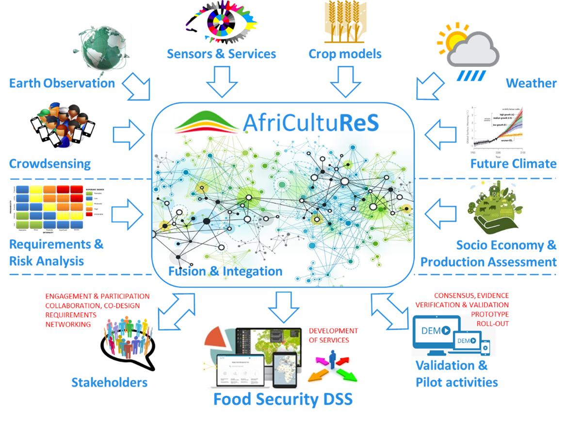 |
EU-H2020-SFS-43-2017 "Enhancing food security in African agricultural systems with the support of remote sensing - AfriCultuReS", 2017 - 2021, http://africultures.eu/ AfriCultuReS aimed to design, implement and demonstrate an integrated agricultural monitoring and early warning system in order to support decision making in the field of food security. To address this challenge, AfriCultuReS provided multi-scale geospatial information and analytic tools in order to enrich and improve decision making at different levels, from the policy maker down to the smallholder farmer or herder scale. AfriCultuReS integrated Earth Observation (EO) data, in situ information, crop models, weather forecasts, seasonal climate predictions, long term climate projections and socio-economic and agronomic parameters that support science-backed decision making. Moreover, AfriCultuReS applied geospatial science and enabling technologies to implement a user driven digital solution that improve agricultural policy and food production, based on a combination of services and products related to Climate, Crop, Drought, Land Use and Land Cover, Livestock, Water and Weather forecast. The services were brought together in the AfriCultuReS Platform and data infrastructure (http://africultures-platform.eu, https://africultures-climate.eu), providing in-country oversight. All in all, AfriCultuReS is a one-stop-shop for decision making in the field of food security in Africa whose long-term vision is to be a Digital Innovation Hub for Food Security in Africa. https://cordis.europa.eu/project/id/774652https://cordis.europa.eu/project/id/774652 |
| |
EU-H2020-eInfra-21-2017 "European e-Infrastructure for Extreme Data Analytics in Sustainable Development - EUXDAT", 2017 - 2020, http://www.euxdat.eu/ EUXDAT presented an innovative e-Infrastructure that addressed critical issues in agriculture, land monitoring, and energy efficiency to foster sustainable development and support planning policies. The project focused on managing and processing vast and diverse datasets by utilizing mature components and High-Performance Computing - HPC and Cloud-based infrastructure. The advanced frontend allowed users to develop applications with a range of data analytic tools and enhanced data catalogs, providing Large Data Analytics-as-a-Service. The integrated e-Infrastructure encouraged end-users to create new applications, contributing to sustainable development efforts. http://www.euxdat.eu/ |
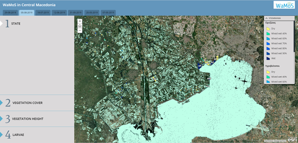 |
WaMoS: Monitoring of surface waters with remote sensing for the rational use of insecticides in wide area mosquito control (ERDF of the EU and Greek national funds, Operational Program Competitiveness, Entrepreneurship and Innovation, RESEARCH – CREATE – INNOVATE Call (2018-2022, T1EDK-05106). Mapping of potential mosquitoes breeding sites is a key element for decision support considering integrated larviciding mosquito control projects in wide areas. In this context, WaMOS aimed to design a Decision Support System (DSS) for targeted and effective larvicide applications in mosquito breeding habitats. The study area included coastal wetlands and rice-paddies in the Central Macedonia Region. A methodology was developed, taking advantage of up-to-date Earth Observation (EO) technology and the availability of free satellite data (ESA Sentinel SAR images) to detect the presence of surface water in mosquito habitats on a regular basis. A predictive machine learning model was developed using a large dataset of field inspections, a collection of open-source topographic, environmental, meteorological information, and the EO-derived surface water maps and vegetation indices. The latter model improved the comprehension of critical parameters affecting larvae productivity and the operational scheduling in larvae monitoring and control actions. Moreover, a webGIS service was developed. All the above contributed to reinforce decision making for appropriate control strategies, the optimization of resource allocation, the preparedness and effective response to emergencies, and a shift from responsive to preventive control measures. https://ecodev.gr/erevnitiko-ergo-wamoshttps://ecodev.gr/erevnitiko-ergo-wamos (in Greek) |
| |
EU-FP7 "Merging hydrological models and Earth observation data for reliable information on water - MyWater", 2011-2013, http://mywater-fp7.eu The MyWater project aimed to provide reliable information on water quantity, quality and usage for appropriate water management. This objective was reached by conducting coordinated research in three areas: Earth Observation (EO), catchment modelling and meteorology. Data from these different sources were integrated through a unique interface platform, which provided to the water manager user-tailored results, such as agriculture water needs, flood scenarios, and desertification scenarios. EO was used to identify Land Cover and Land Use (LCLU), and to estimate Actual Evapotranspiration (ETa), Leaf Area Index (LAI) and Soil Moisture. Catchment models simulated these parameters as well and allowed confirming or complementing the satellite data. Meteorological information, such as Precipitation and Temperature was needed as input to the catchment models to determine the water availability. |
| |
EU-ERDF "Joint reference strategies for rural activities of reduced inputs in precision agriculture - AgroLess", 2013-2015, http://agrolessproject.eu/ The objectives of the AGRO_LESS project was to customize digital services and support the cross-border farmers in the application of precision farming. This was achieved through site-specific fertilization, irrigation and crop protection, leading to reduced impact of agro-products on the environment and increased produce quality. Additional outputs include proposed areas for the application of Reduced input agriculture protocols in the area of the Central Macedonia Region based on multi-criteria analysis and the creation of vertical clusters and a regulatory body providing expertise and services to the rural population. |
Other projects:
- ICT-Agri Call 2, FarmFUSE: “Fusion of multi-source and multi-sensor information on soil and crop for optimised crop production system” 2013-2016.
- FP7, KBBE, 2007-1, project FUTUREFARM: "Integration of Farm Management Information Systems to support real-time management decisions and compliance of management standards".
- QLRT-1999-01280, OPTIDIS: "Prototype data fusion system for autonomous crop monitoring".
- FRACTALS subproject AGROMENTORIS: "Smartphone app for crop disease recognition", 2015-2016.
In climate modeling:
- EURO-CORDEX, European Coordinated Regional Downscaling Experiment (Co-Coordinator), http://www.euro-cordex.net/.
- EU, Copernicus Atmosphere Monitoring Service (CAMS-84): Global and regional a posteriori validation, including focus on the Arctic and Mediterranean areas, 10/2015 – 9/2018, https://atmosphere.copernicus.eu/.
- EC, FP7, Environmental Optimization of IRrigAtion Management with the Combine uSe and Integration of High PrecisIon Satellite Data, Advanced Modeling, Process Control and Business Innovation (ENORASIS), 2012-2015, http://www.enorasis.eu/.
- EC, FP6, Global and Regional Earth-System Monitoring using Satellite and in-situ data, (GEMS) 2005-2009, http://cordis.europa.eu/result/rcn/85751_en.html
In meteorological forecasting:
- EC, MARIE CURIE/TMR, African Easterly Waves and their transformation into tropical cyclones, 1997-1998, https://cordis.europa.eu/tmr/src/grants/fmbi/961444.htm.
- TSUNAMI initiative (Corporation of Insurance Companies and the British Government), Seasonal prediction of tropical cyclogenesis in northern Atlantic with the use of atmospheric numerical models, 1999
- EC & GSRT, A high-resolution forecasting system for maritime and other applications (NIREAS), 1999-2001
- Ministry of Culture/General Secretariat of Olympic Games – ATHENS2004, Development and installation of special versions of the numerical weather and wave prediction models SKIRON/Eta, RAMS, LAPS, WAM for the Olympic Games of 2004, 2002-2004
- EC, Automated fire and flood hazard protection system (AUTOHAZARD-PRO), 2002-2004, http://cordis.europa.eu/project/rcn/60351_en.html.
- GSRT, Weather forecasting services through the internet and mobile telephones (PRAXE), 2003
- EC, Mediterranean Forecasting System Toward Environmental Predictions (MFSTEP), 2003-2006, http://mfstep.bo.ingv.it/.
- NSRF 2007-2013 (National Strategic Reference Framework) & ERDF, An Innovative and Integrated Conceptual Model to Mitigate the Impact of Climate Change on Drought: Potentiality and Applicability of a Precipitation Enhancement Project in Thessaly (DAPHNE), 2013-2015, http://www.daphne-meteo.gr/.